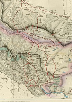
印地他什达坂
印地他什达坂,又称印地他什山口,是中国新疆西部的一座历史山口。山口穿过昆仑山脉,连接喀拉喀什河河谷的康西瓦和普夏达里亚河河谷的普夏村。(36°23′0″N 79°0′0″E / 36.38333°N 79.00000°E )。它还连接到通往和田市的道路。[1]
| 印地他什达坂 | |
|---|---|
 | |
| 海拔 | 5,450米(17,880英尺) |
| 穿過 | |
| 位置 | 中国新疆和田縣 |
| 山脉 | 昆仑山脉 |
| 坐标 | 36°16′23″N 78°46′50″E / 36.27306°N 78.78056°E |

![]() 580国道正在建设中,计划将康西瓦与和田市直接连接起来。[2]自和田市—朗如乡,经过墨玉县阿提塔克亚兴建阿提塔克亚隧道穿越阿提塔克亚达坂,在(K158+418)处拟规划建庞纳子水库(36°33′00″N 79°03′18″E / 36.55000°N 79.05500°E),海拔高度2450-2500m。测量时水位为2278.52m,水库规划蓄水位为2440m。在(K168+610)处兴建庞纳子大桥橫越普夏达里亚河,在印地他什达坂兴建昆仑山隧道穿越印地他什达坂,国道最后终点在康西瓦。
580国道正在建设中,计划将康西瓦与和田市直接连接起来。[2]自和田市—朗如乡,经过墨玉县阿提塔克亚兴建阿提塔克亚隧道穿越阿提塔克亚达坂,在(K158+418)处拟规划建庞纳子水库(36°33′00″N 79°03′18″E / 36.55000°N 79.05500°E),海拔高度2450-2500m。测量时水位为2278.52m,水库规划蓄水位为2440m。在(K168+610)处兴建庞纳子大桥橫越普夏达里亚河,在印地他什达坂兴建昆仑山隧道穿越印地他什达坂,国道最后终点在康西瓦。
和康公路将在印地他什达坂兴建昆仑山隧道穿越印地他什达坂,向北经过无数发夹弯连接普夏村,向南经过无数发夹弯在康西瓦后与新藏公路![]() 219国道连接。[3]隧道计划将于2022年完成贯通。[4]
219国道连接。[3]隧道计划将于2022年完成贯通。[4]
参见
编辑参考
编辑- ^ 1.0 1.1 Trotter, H., On the Geographical Results of the Mission to Kashghar, under Sir T. Douglas Forsyth in 1873-74, Journal of the Royal Geographical Society of London, 1878, 48 (2): 173–234 [2022-03-27], JSTOR 1798763, doi:10.2307/1798763, (原始内容存档于2020-10-28)
- ^ Zeng, Tao-rui; Wang, Lin-feng. The Reliability and Stability Analysis of High Shear Slope in Cold Region Based on First Order Quadratic Matrix. Science Technology and Engineering (kns.ccpd.cnki.net). 2019, (21) [7 January 2020]. ISSN 1671-1815.
Taking the K86 + 780 ~ K86 + 840 soil high cut slope of the highway section from Hetian to Kangxiwa of G580 line as an example,the reliability calculation of soil high cut slope in the cold region was carried out
[失效連結] - ^ 新疆G580线和田至康西瓦公路PPP项目施工总承包指挥部 [Xinjiang G580 line Hotan to Kangxiwar road PPP project construction general contracting HQ]. gonglutielu.com. 2017-08-28 [7 January 2020]. (原始内容存档于2022-04-09) (中文).
于印地他什达坂设隧道,出洞后沿等高线展线而下,最终与G219相接。
- ^ 中国交通新闻网. 580国道和康项目一标完成路面摊铺 [G580 Hotan-Kangxiwar Project first milestone completed, road surface paved]. 中华人民共和国交通运输部. 2019-11-18 [7 January 2020].
日前,580国道新疆和田至康西瓦公路项目一标主线沥青路面完成摊铺,为2022年全线通车奠定了坚实基础。
[失效連結]
| 喀喇昆仑走廊和阿克赛钦的相关位置图 |
|---|
|
喀喇昆仑走廊和阿克赛钦的相关位置图 图例: 6:布洛阿特峰 7:加舒尔布鲁木IV峰 K3 8:加舒尔布鲁木II峰 K4 9:加舒尔布鲁木I峰 K5 10:锡亚康戈里峰 11:特拉木坎力I峰 12:Apsarasas Kangri I 13:皇冠山 14:克勒青河 15:喀喇昆仑山口 16:斗拉特别奥里地 - 天文点 LAC 17:加勒万河 18:空喀山口 19:神仙湾 20:天文点 21:河尾滩 22:加勒万前进基地 23:溫泉 24:空喀山口边防连 25:空喀山口事件 (胜利山) 26:拉那克山口 27:阿克赛钦湖 28:甜水海 29:喀拉喀什河 30:叶尔羌河 31:热斯喀木村(Raskam) 32:麻扎(Mazar) 33:柯克阿特达坂 34:赛图拉哨卡(Xaidulla) 35:赛图拉镇 36:康西瓦(Kangxiwar) 37:大红柳滩(Dahongliutan) 38:Suget Pass 39:桑株达坂 40:印地他什达坂 41:莎车县莎车镇 42:喀格勒克镇 43:博热(Bora) 44:柯克亚乡 45:固玛镇 46:桑株镇 47:和田市 48:于田县 49:玉龙喀什河 50:克里雅河 51:克里雅山口 52:郭扎错 53:邦达错 54:清澈湖 55:美马错 56:龙木错 57:松西村 |
