特威克納姆
特威克納姆(Twickenham)是英國倫敦西南部的一個地區,在行政區劃上屬於泰晤士河畔里奇蒙倫敦自治市。特威克納姆位於倫敦市中心西南10英里(16公里)處[3],在1965年被劃入大倫敦地區[4]。
| Twickenham | |
|---|---|
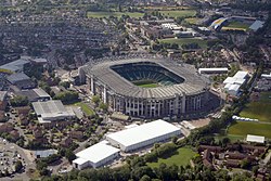
 Aerial view of Twickenham Stadium (centre) and Stoop Stadium (background) from the north in August 2015 | |
| 坐標:51°26′55″N 0°20′13″W / 51.4486°N 0.3369°W | |
| 主權國家 | 英國 |
| 國家 | 英格蘭 |
| 區域 | |
| 面積 | |
| • 總計 | 12.36 平方公里(4.77 平方英里) |
| 人口(2011 Census Heathfield, St Margarets and North Twickenham, South Twickenham, Twickenham Riverside and West Twickenham wards 2011)[1][2] | |
| • 總計 | 52,396人 |
| • 密度 | 4,239人/平方公里(10,979人/平方英里) |
| 郵鎮(郵區) | TWICKENHAM(TW1, TW2) |
| 電話區號 | 020 |
| OS 格網參考 | TQ1673 |
| • 查令十字 | 10 mi(16 km) NE |
| 名譽郡 | 大倫敦 |
| 警察 | 倫敦警察廳 |
| 消防 | 倫敦消防隊 |
| 救護 | 倫敦救護站 |
| 英國國會選區 | |
參考資料
編輯- ^ Census Information Scheme. 2011 Census Ward Population Estimates. Greater London Authority. 2012 [30 January 2013].
- ^ Key Statistics; Quick Statistics: Population Density (頁面存檔備份,存於網際網路檔案館) United Kingdom Census 2011 Office for National Statistics. Retrieved 21 November 2013
- ^ Mayor of London. London Plan (Consolidated with Alterations since 2004) (PDF). Greater London Authority. February 2008 [6 August 2009]. (原始內容存檔 (PDF)於2010-06-02).
- ^ Young, K. & Garside, P.,. Metropolitan London: Politics and Urban Change 1837–1981. 1982.