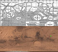
File:Schiaparelli versus Mars.jpg

預覽大小:666 × 599 像素。 其他解析度:267 × 240 像素 | 534 × 480 像素 | 854 × 768 像素 | 1,138 × 1,024 像素 | 1,823 × 1,640 像素。
原始檔案 (1,823 × 1,640 像素,檔案大小:2.13 MB,MIME 類型:image/jpeg)
檔案歷史
點選日期/時間以檢視該時間的檔案版本。
| 日期/時間 | 縮圖 | 尺寸 | 用戶 | 備註 | |
|---|---|---|---|---|---|
| 目前 | 2012年8月8日 (三) 22:41 |  | 1,823 × 1,640(2.13 MB) | Wnt | Side by side comparison of Schiaparelli's 1888 map of Mars (File:Karte Mars Schiaparelli MKL1888.png) with a modern satellite map (File:Mars Géolocalisation.jpg). As was previously commented for Pioneer data,<sup>[http://www.agu.org/pubs/cros... |
檔案用途
下列2個頁面有用到此檔案:
全域檔案使用狀況
以下其他 wiki 使用了這個檔案:
- el.wiki.x.io 的使用狀況
- en.wiki.x.io 的使用狀況
- es.wiki.x.io 的使用狀況
- ga.wiki.x.io 的使用狀況
- it.wiki.x.io 的使用狀況
- no.wiki.x.io 的使用狀況
- pl.wiki.x.io 的使用狀況
- ru.wiki.x.io 的使用狀況


