曼徹斯特 (新罕布什爾州)
曼徹斯特(英語:Manchester)是美國新罕布什爾州希爾斯波羅縣兩個縣治之一。[4]2006年人口109,497人,[5]是該州最大城市。這個數字於2010年上升至109,565人。[6]
| 曼徹斯特 Manchester | |
|---|---|
| 城市 | |
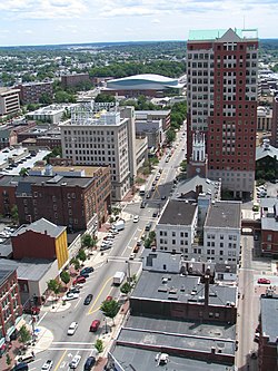
 Elm Street | |
| 綽號:皇后城、曼徹維加斯 Queen City, Manch Vegas | |
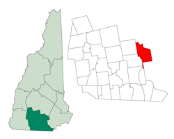
 曼徹斯特在新罕布什爾州的位置 | |
| 坐標:42°59′27″N 71°27′49″W / 42.9908°N 71.4636°W | |
| 國家 | 美國 |
| 州 | 新罕布什爾州 |
| 縣 | 希爾斯波羅縣 |
| 成立市政機關 | 1751年 |
| 政府 | |
| • 市長 | 特德·蓋特沙 |
| • 市議員 | 喬伊斯·克雷格 羅恩·路德維希 帕特里克·朗 吉姆·羅伊 埃德·奧斯本 加思·科里沃 威廉·P·佘 托馬斯·吉仙托尼斯 芭芭拉·E·肖 菲爾·克雷亞佐 諾曼德·加馬什 帕特里克·阿諾德 約瑟夫·凱利·萊維塞爾 丹尼爾·P·奧尼爾 |
| 面積 | |
| • 城市 | 34.9 平方英里 (90.4 平方公里) |
| • 陸地 | 33.0 平方英里(85.5 平方公里) |
| • 水域 | 1.9 平方英里(4.9 平方公里) 5.44% |
| 海拔 | 210 英尺(64 公尺) |
| 人口(2012)[1][2][3] | |
| • 城市 | 110,209(第241位)人 |
| • 密度 | 3,320.2人/平方英里(1,281.5人/平方公里) |
| • 市區 | 158,377(第209位) |
| • 都會區 | 402,922(第131位) |
| 時區 | 北美東部時區(UTC-5) |
| • 夏時制 | 北美東部時區(UTC-4) |
| ZIP代碼 | 03101-03111 (03110 assigned to suburb Bedford) |
| 電話區號 | 603 |
| FIPS代碼 | 33-45140 |
| GNIS代碼 | 0868243 |
| 網站 | www |
1751年建城,名為德里菲爾德(Derryfield)。1810年改為今名。[7]
地理
編輯曼徹斯特的座標為42°59′11″N 71°27′6″W / 42.98639°N 71.45167°W(42.986284,-71.451560)。[8]根據2000年人口普查,本城面積為34.9平方英里(90.39平方公里),其中33.0平方英里(85.47平方公里)為陸地,1.9平方英里(4.92平方公里)為水域。[9]
| 新罕布什爾州曼切斯特–波士頓區域機場(1991–2020年正常值,1885年至今極端數據) | |||||||||||||
|---|---|---|---|---|---|---|---|---|---|---|---|---|---|
| 月份 | 1月 | 2月 | 3月 | 4月 | 5月 | 6月 | 7月 | 8月 | 9月 | 10月 | 11月 | 12月 | 全年 |
| 歷史最高溫 °C(°F) | 21 (70) |
25 (77) |
29 (85) |
34 (94) |
36 (97) |
38 (100) |
39 (103) |
38 (100) |
38 (100) |
31 (88) |
26 (78) |
23 (74) |
39 (103) |
| 平均最高溫 °C(°F) | 13.2 (55.8) |
13.7 (56.7) |
19.3 (66.7) |
27.7 (81.9) |
32.3 (90.1) |
33.9 (93.0) |
34.7 (94.5) |
33.9 (93.0) |
32.0 (89.6) |
26.2 (79.2) |
20.6 (69.1) |
15.8 (60.5) |
35.9 (96.7) |
| 平均高溫 °C(°F) | 1.2 (34.1) |
3.0 (37.4) |
7.6 (45.6) |
14.9 (58.9) |
21.2 (70.1) |
25.9 (78.7) |
28.9 (84.1) |
28.0 (82.4) |
23.7 (74.6) |
16.7 (62.1) |
10.0 (50.0) |
4.1 (39.3) |
15.4 (59.8) |
| 平均低溫 °C(°F) | −8.3 (17.1) |
−7.2 (19.0) |
−2.6 (27.4) |
3.1 (37.5) |
8.7 (47.7) |
14.2 (57.6) |
17.6 (63.6) |
16.7 (62.1) |
12.3 (54.1) |
5.7 (42.3) |
0.5 (32.9) |
−4.7 (23.5) |
4.7 (40.4) |
| 平均最低溫 °C(°F) | −19.0 (−2.2) |
−16.7 (2.0) |
−12.7 (9.2) |
−3.1 (26.5) |
1.9 (35.4) |
7.7 (45.8) |
12.6 (54.7) |
10.7 (51.2) |
4.3 (39.7) |
−1.6 (29.1) |
−7.2 (19.0) |
−14.3 (6.3) |
−20.3 (−4.6) |
| 歷史最低溫 °C(°F) | −32 (−26) |
−34 (−29) |
−28 (−18) |
−11 (13) |
−4 (25) |
1 (34) |
2 (36) |
4 (40) |
−2 (28) |
−11 (13) |
−16 (4) |
−29 (−20) |
−34 (−29) |
| 平均降水量 mm(吋) | 62 (2.44) |
69 (2.73) |
88 (3.45) |
85 (3.33) |
86 (3.38) |
103 (4.04) |
84 (3.30) |
85 (3.35) |
94 (3.72) |
99 (3.88) |
88 (3.48) |
84 (3.29) |
1,027 (40.39) |
| 平均降水天數(≥ 0.01 in) | 10.0 | 9.5 | 10.8 | 11.4 | 12.4 | 12.8 | 11.1 | 10.3 | 9.2 | 11.0 | 10.3 | 10.7 | 129.5 |
| 數據來源:NOAA[10][11] | |||||||||||||
姐妹城市
編輯參考文獻
編輯- ^ United States Census Bureau, American FactFinder (頁面存檔備份,存於互聯網檔案館), 2010 Census figures. Retrieved March 23, 2011.
- ^ Race, Hispanic or Latino, Age, and Housing Occupancy: 2010 Census Redistricting Data (Public Law 94-171) Summary File (QT-PL), Manchester, NH Metropolitan NECTA. U.S. Census Bureau, American FactFinder 2. [August 17, 2011]. (原始內容存檔於2013-09-11).
- ^ Race, Hispanic or Latino, Age, and Housing Occupancy: 2010 Census Redistricting Data (Public Law 94-171) Summary File (QT-PL), Manchester-Nashua, NH Metro Area. U.S. Census Bureau, American FactFinder 2. [September 7, 2011]. (原始內容存檔於2013-09-11).
- ^ Find a County. National Association of Counties. [2011-06-07].
- ^ 美國人口普查局,Manchester city, New Hampshire - Population Finder - America Factfinder[永久失效連結]
- ^ 2010 census factfinder2. [2013-08-08]. (原始內容存檔於2013-09-11).
- ^ Brooks, Scott. ManchVegas: Love it or hate it, the Queen City's other name has stuck. New Hampshire Union Leader. 2005-10-26 [2011-01-20]. (原始內容存檔於2018-09-08).
- ^ US Gazetteer files: 2010, 2000, and 1990. United States Census Bureau. 2011-02-12 [2011-04-23].
- ^ US Gazetteer files 2010. United States Census Bureau. [2013-01-25]. (原始內容存檔於2012-07-14).
- ^ Summary of Monthly Normals 1991–2020 (pdf). National Oceanic and Atmospheric Administration. [2021-10-30]. (原始內容存檔於2021-10-30).
- ^ NowData – NOAA Online Weather Data. National Oceanic and Atmospheric Administration. [2021-10-30]. (原始內容存檔於2021-11-12).