北灘 (三藩市)
舊金山東北部街區
37°48′1.04″N 122°24′36.66″W / 37.8002889°N 122.4101833°W
| 北灘 | |
|---|---|
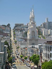
 位於北灘的聖伯多祿聖保祿教堂 | |
| 坐標:37°48′01″N 122°24′37″W / 37.800288888889°N 122.41018333333°W | |
| 面積[1] | |
| • 總計 | 2 平方公里(0.620 平方英里) |
| • 陸地 | 2 平方公里(0.620 平方英里) |
| 人口(2008)[1] | |
| • 總計 | 20,171人 |
| • 密度 | 12,571人/平方公里(32,558人/平方英里) |
| ZIP Code | 94111, 94133 |
| 電話區號 | 415 |
北灘(North Beach)是三藩市東北部的一個街區,毗鄰唐人街和漁人碼頭。它被認為是三藩市的「小意大利」,因為意大利裔移民曾經占該區人口的大多數。北灘也是三藩市主要的紅燈區和夜生活區域。
北灘的主要街道有聯合街(Union Street)、哥倫布大道(Columbus Avenue)、華盛頓廣場(Washington Square)、都板街(Grant Avenue)和瓦列霍街(Vallejo Street)等。俄羅斯山在西面,電報山在東面,灣街(Bay Street)以北是漁人碼頭。
美國規劃協會(American Planning Association)將北灘稱為美國10大街區之一[2]。
外部連結
編輯- North Beach Interactive Neighborhood Map: Hilton SF
- Guided photo tour(頁面存檔備份,存於互聯網檔案館)
- The Chronicle's standing article about North Beach(頁面存檔備份,存於互聯網檔案館)
- North Beach Neighbors a San Francisco Neighborhood Organization(頁面存檔備份,存於互聯網檔案館)
- Surrounded by Sound: Aurally Exploring the Barbary Coast(頁面存檔備份,存於互聯網檔案館) at en fuego magazine
- Historic North Beach and Telegraph Hill photographs by photographer JB Monaco