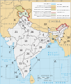
File:Political map of India EN.svg

此SVG文件的PNG预览的大小:511 × 599像素。 其他分辨率:205 × 240像素 | 410 × 480像素 | 655 × 768像素 | 874 × 1,024像素 | 1,748 × 2,048像素 | 1,594 × 1,868像素。
原始文件 (SVG文件,尺寸为1,594 × 1,868像素,文件大小:337 KB)
文件历史
点击某个日期/时间查看对应时刻的文件。
| 日期/时间 | 缩略图 | 大小 | 用户 | 备注 | |
|---|---|---|---|---|---|
| 当前 | 2024年5月25日 (六) 22:37 |  | 1,594 × 1,868(337 KB) | Gegot | File uploaded using svgtranslate tool (https://svgtranslate.toolforge.org/). Added translation for de. |
| 2024年5月25日 (六) 16:48 |  | 1,594 × 1,868(337 KB) | Gegot | File uploaded using svgtranslate tool (https://svgtranslate.toolforge.org/). Added translation for de. | |
| 2022年9月28日 (三) 13:49 |  | 1,594 × 1,868(325 KB) | ऐक्टिवेटेड् | File uploaded using svgtranslate tool (https://svgtranslate.toolforge.org/). Added translation for sa. | |
| 2022年8月27日 (六) 19:30 |  | 1,594 × 1,868(312 KB) | Johano | File uploaded using svgtranslate tool (https://svgtranslate.toolforge.org/). Added translation for eo. | |
| 2022年8月23日 (二) 22:34 |  | 1,594 × 1,868(310 KB) | Johano | File uploaded using svgtranslate tool (https://svgtranslate.toolforge.org/). Added translation for eo. | |
| 2020年7月3日 (五) 05:30 |  | 1,594 × 1,868(300 KB) | Jfblanc | removed I-mark and replaced by H (thanks Wassermaus!) | |
| 2020年4月7日 (二) 15:56 |  | 1,594 × 1,868(299 KB) | Jfblanc | Merger of UTs of Dadra & Nagar Haveli with Daman and Diu (26 January 2020). | |
| 2019年11月19日 (二) 07:47 |  | 1,594 × 1,868(293 KB) | Getsnoopy | Complete code overhaul for easier manipulation. Corrected JK and Ladakh border in PaK. Adjusted some label positions and some other styles. | |
| 2019年11月8日 (五) 20:12 |  | 1,594 × 1,868(318 KB) | Getsnoopy | Reverted to version as of 14:11, 2 November 2019 (UTC) | |
| 2019年11月8日 (五) 20:10 |  | 1,594 × 1,868(291 KB) | Getsnoopy | Complete code overhaul for easier manipulation. Corrected JK and Ladakh border in PaK. Adjusted some label positions and some other styles. |
文件用途
以下4个页面使用本文件:
全域文件用途
以下其他wiki使用此文件:
- ace.wiki.x.io上的用途
- as.wiki.x.io上的用途
- bat-smg.wiki.x.io上的用途
- be-tarask.wiki.x.io上的用途
- bh.wiki.x.io上的用途
- bn.wiki.x.io上的用途
- bs.wiki.x.io上的用途
- cs.wiki.x.io上的用途
- da.wiki.x.io上的用途
- en.wiki.x.io上的用途
- India
- List of Indian state and union territory name etymologies
- Outline of India
- Talk:States of India
- Template:Indian states and territories image map
- User:RajatTikmany
- User:Srujan1001/sandbox
- User:RexxS/India (no clear)
- User:RexxS/India (20em cols)
- User:RexxS/India (15em cols)
- User:Berek/India
- Talk:India/Archive 46
- User:Fowler&fowler/India
- eo.wiki.x.io上的用途
- es.wiki.x.io上的用途
- fi.wiki.x.io上的用途
- fr.wiki.x.io上的用途
- gl.wiki.x.io上的用途
- he.wiki.x.io上的用途
查看此文件的更多全域用途。
