原始文件 (1,150 × 920像素,文件大小:153 KB,MIME类型:image/png


此geology图片可使用矢量图形重新创建为SVG文件。这具有很多好处;更多信息请参见共享资源:待清理媒体。如果存在此图片的SVG格式,请将其上传,然后将此模板替换为{{vector version available|新图片名称}}


建议您将SVG命名为“Kuunga2.svg”,这样在使用Vector version available(或Vva)模板时就不需要填写新图片名称参数。

摘要

描述
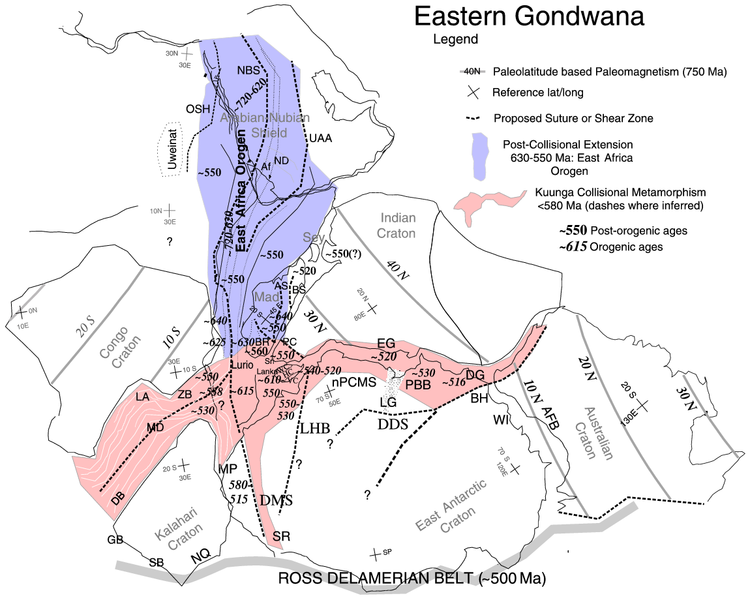
English: Paleotectonic map of eastern Gondwana with the Pan-African and/or circum-Antarctic orogenic (“mobile”) belts highlighted by age differences (See Fitzsimons, 2000a, cited in Meert, 2003, follow source link below). Meaning of abbreviations: Af = Afif terrane (Saudi Arabia); AFB = Albany-Fraser Belt (Australia); AS = Angavo shear zone (Madagascar); BH = Bunger Hills (Antarctica); BR = Bongolava-Ranotsara shear zone (Madagascar); BS = Betsimisaraka suture zone (Madagascar); DB = Damara Belt (Africa); DDS = Darling-Denman suture (Antarctica - Australia); DG = Denman Glacier (Antarctica); DMS = Dronning Maud suture (Antarctica); EG = Eastern Ghats (India); GB = Gariep Belt (Africa); HC = Highland Complex (Sri Lanka); LA = Lufilian Arc (Africa); LG = Lambert Graben (Antarctica); LHB = Lützow-Holm Belt (Antarctica); MD = Mwembeshi Dislocation (Africa); MP = Maud Province (Antarctica); NBS = Nabitah Suture (Arabia); nPCSM = Northern Prince Charles Mountains (Antarctica); NQ = Namaqua Belt (Africa); OSH = Onib-Sol Hamed suture (Arabia); PBB = Prydz Bay Belt (Antarctica); PC = Paughat-Cauvery (India); SB = Saldania Belt (Africa); SR = Shackelton Range (Antarctica) ; UAA = Urd Al Amar suture (Arabia); VC = Vijayan Complex (Sri Lanka); WC = Wanni Complex (Sri Lanka); WI = Windmill Islands (Antarctica); ZB = Zambezi Belt (Africa).
日期 (UTC)
来源 Kuunga2.jpg
作者

许可协议

我,本作品著作权人,特此采用以下许可协议发表本作品:
本作品已被作者[[::|中文维基百科]]项目的Example释出到公有领域。这适用于全世界。

如果这样做不合法的话:
Example无条件地授予任何人以任何目的使用本作品的权利,除非这些条件是法律规定所必需的。

原始上传日志

This image is a derivative work of the following images:

  • File:Kuunga2.jpg licensed with PD-user-w
    • 2008-02-29T10:16:24Z File Upload Bot (Magnus Manske) 1000x785 (220296 Bytes) {{BotMoveToCommons|en.wikipedia}} {{Information |Description={{en|http://www.clas.ufl.edu/users/jmeert/kuunga.jpg adapted from: Meert, J.G., A synopsis of events related to the assembly of eastern Gondwana, Tectonophysics,

Uploaded with derivativeFX

说明

添加一行文字以描述该文件所表现的内容
Paleotectonic map of eastern Gondwana with the Pan-African and/or circum-Antarctic orogenic

此文件中描述的项目

描绘内容

冈瓦那大陆 中文(已转写)

版权状态 简体中文(已转写)

媒体类型 简体中文(已转写)

image/png

文件历史

点击某个日期/时间查看对应时刻的文件。

日期/时间缩⁠略⁠图大小用户备注
当前2010年11月8日 (一) 00:082010年11月8日 (一) 00:08版本的缩略图1,150 × 920(153 KB)Mikhail Ryazanov{{Information |Description={{en|Orogens and Kuungan Orogens.}} |Source=*File:Kuunga2.jpg |Date=2010-11-08 00:06 (UTC) |Author=*File:Kuunga2.jpg: Jmeert *derivative work: ~~~ |Permission= |other_versions= }} {{self|PD-user-

以下3个页面使用本文件:

全域文件用途

元数据