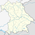
File:Bavaria location map.svg

此SVG文件的PNG预览的大小:608 × 600像素。 其他分辨率:243 × 240像素 | 487 × 480像素 | 779 × 768像素 | 1,038 × 1,024像素 | 2,077 × 2,048像素 | 867 × 855像素。
原始文件 (SVG文件,尺寸为867 × 855像素,文件大小:738 KB)
文件历史
点击某个日期/时间查看对应时刻的文件。
| 日期/时间 | 缩略图 | 大小 | 用户 | 备注 | |
|---|---|---|---|---|---|
| 当前 | 2009年11月19日 (四) 17:22 |  | 867 × 855(738 KB) | Alexrk2 | fixed boundaries, rivers; adjusted map projection; colors for internal divisions |
| 2009年3月28日 (六) 20:01 |  | 867 × 855(1.05 MB) | TUBS | #corrected 4 mistakes (lake margins (pasted to foreground), RegBez and counties around TIR (splited area in two counties and corrected RegBez border), County of Munich (merged), Merged an (to me right know unknown) county north of Nuremberg. #moved all gr | |
| 2009年1月28日 (三) 09:32 |  | 867 × 855(1.45 MB) | TUBS | {{Information |Description= |Source= |Date= |Author= |Permission= |other_versions= }} | |
| 2009年1月28日 (三) 00:20 |  | 867 × 855(1.45 MB) | TUBS | {{Information |Description= |Source= |Date= |Author= |Permission= |other_versions= }} | |
| 2009年1月27日 (二) 00:11 |  | 867 × 855(1.46 MB) | TUBS | {{Information |Description= |Source= |Date= |Author= |Permission= |other_versions= }} | |
| 2009年1月26日 (一) 23:20 |  | 867 × 855(1.5 MB) | TUBS | {{Information |Description= |Source= |Date= |Author= |Permission= |other_versions= }} | |
| 2009年1月26日 (一) 11:38 |  | 867 × 855(1.51 MB) | TUBS | == Summary == {{Information |Description= {{de|Positionskarte Hessen, Deutschland. Geographische Begrenzung der Karte:}} {{en|Location map Bavaria, Germany. Geographic limits of the map:}} * N: 50.6303000° N * S: 47.26618 | |
| 2009年1月26日 (一) 11:24 |  | 867 × 855(1.52 MB) | TUBS | == Summary == {{Information |Description= {{de|Positionskarte Hessen, Deutschland. Geographische Begrenzung der Karte:}} {{en|Location map Bavaria, Germany. Geographic limits of the map:}} * N: 50.6303000° N * S: 47.26618 |
文件用途
以下60个页面使用本文件:
- 2017年至2018年德国足球巴伐利亚地区联赛
- 2018年至2019年德国足球巴伐利亚地区联赛
- 2019年至2021年德国足球巴伐利亚地区联赛
- 2021年至2022年德国足球巴伐利亚地区联赛
- 2022年至2023年德国足球巴伐利亚地区联赛
- 2023年至2024年德国足球巴伐利亚地区联赛
- 下格里斯巴赫
- 伊尔姆河畔普法芬霍芬
- 伊萨尔河畔沃尔特
- 伊萨尔河谷普拉赫
- 克林 (德国)
- 勒特莱恩
- 勞特塔爾 (巴伐利亞州)
- 哈旺根
- 哈格 (巴伐利亚)
- 圣亚纳圣殿 (旧厄廷)
- 圣伯多禄圣亚历山大圣殿
- 圣母圣诞圣殿 (雷根斯堡)
- 基希安舍灵
- 基明
- 多瑙沃特
- 多瑙河畔诺伊堡
- 安斯巴赫
- 巴伐利亞國家博物館
- 巴特赖兴哈尔
- 希尔绍
- 庫爾姆巴赫
- 弗里德贝格 (巴伐利亚州)
- 德國足球俱樂部列表
- 恩斯多夫 (巴伐利亚州)
- 慕尼黑-里姆机场
- 慕尼黑机场
- 施瓦巴赫
- 施瓦本地区克伦巴赫
- 柯尼希湖畔舍瑙
- 格隆河畔普法芬霍芬
- 格雷弗尔芬
- 梅明根机场
- 沃尔特
- 洛伊希滕贝格宫
- 瓦尔德纳布河畔诺伊施塔特
- 福希海姆
- 紐倫堡交通博物館
- 罗特河畔普法芬霍芬
- 贝岑施泰因
- 贡德尔斯海姆 (巴伐利亚州)
- 赖恩
- 赖恩 (下巴伐利亚行政区)
- 里登堡
- 阿尔滕施塔特 (上巴伐利亚)
- 阿尔滕施塔特 (施瓦本)
- 阿德尔斯霍芬
- 阿德尔斯霍芬 (中弗兰肯行政区)
- 阿沙芬堡
- 阿默湖畔雄多夫
- 霍伊施特罗伊
- 魏登巴赫
- Template:Location map Germany Bavaria
- Module:Location map/data/Germany Bavaria
- Module:Location map/data/Germany Bavaria/doc
全域文件用途
以下其他wiki使用此文件:
- af.wiki.x.io上的用途
- als.wiki.x.io上的用途
- ar.wiki.x.io上的用途
- ast.wiki.x.io上的用途
- azb.wiki.x.io上的用途
查看此文件的更多全域用途。


