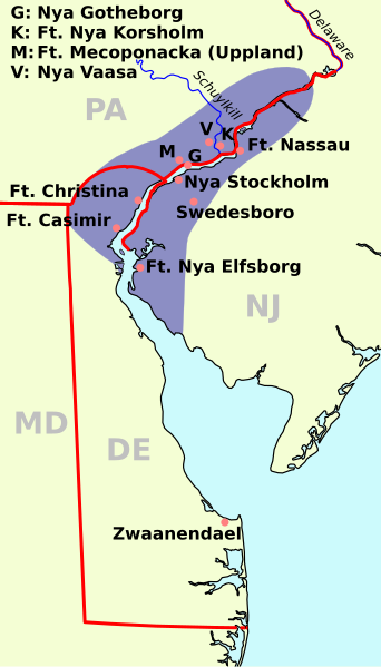
原始檔案 (SVG 檔案,表面大小:720 × 1,260 像素,檔案大小:461 KB)
See also: Nieuw Nederland and Nya Sverige
您可以自由:
分享 – 複製、發佈和傳播本作品重新修改 – 創作演繹作品
惟需遵照下列條件:
姓名標示 – 您必須指名出正確的製作者,和提供授權條款的連結,以及表示是否有對內容上做出變更。您可以用任何合理的方式來行動,但不得以任何方式表明授權條款是對您許可或是由您所使用。相同方式分享 – 如果您利用本素材進行再混合、轉換或創作,您必須基於如同原先的相同或兼容的條款 ,來分布您的貢獻成品。 https://creativecommons.org/licenses/by-sa/3.0 CC BY-SA 3.0 Creative Commons Attribution-Share Alike 3.0 true true
This image is a derivative work of the following images:
File:Nya Sverige.png licensed with Cc-by-sa-3.0-migrated, GFDL, PD-self
2005-10-12T00:50:54Z Arnapha 306x528 (6492 Bytes) Map of New-Sweden ca. 1650 Created on base of the maps of Delaware and New Jersey from the Perry Castañeda Library (at http://www.lib.utexas.edu/maps/united_states.html). Transferred from German Wikipedia (http://de.wikipe File:USA New Jersey location map.svg licensed with Cc-by-3.0, GFDL
2009-06-17T19:59:27Z Alexrk2 839x1560 (259806 Bytes) enh
2009-06-13T18:01:16Z Alexrk 839x1560 (198653 Bytes) fixed SVG bug
2009-06-13T17:46:17Z Alexrk 839x1560 (246056 Bytes) == Beschreibung == {{Information |Description= {{de|Positionskarte von [[:de:New Jersey|New Jersey]], [[:de:USA|USA]]}} Quadratische Plattkarte, N-S-Streckung 130.0 %. Geographische Begrenzung der Karte: * N: 41.6° N * S: 38 File:USA New York location map.svg licensed with Cc-by-3.0, GFDL
2009-06-10T11:28:20Z NordNordWest 1572x1277 (597043 Bytes) {{Information |Description= {{de|Positionskarte vom Bundesstaat [[:de:New York (Bundesstaat)|New York]], [[:de:USA|USA]]}} Quadratische Plattkarte, N-S-Streckung 135 %. Geographische Begrenzung der Karte: * N: 45.3° N * S: 4 File:USA Delaware location map.svg licensed with Cc-by-3.0, GFDL
2009-06-22T10:54:18Z Alexrk2 470x800 (106507 Bytes) renderer bug
2009-06-22T10:39:54Z Alexrk2 470x800 (66078 Bytes) == Beschreibung == {{Information |Description= {{de|Positionskarte von [[:de:Delaware|Delaware]], [[:de:USA|USA]]}} Quadratische Plattkarte, N-S-Streckung 130.0 %. Geographische Begrenzung der Karte: * N: 40.0° N * S: 38.3° Uploaded with derivativeFX
英文 Map of New Sweden, 1638
德文 Karte von Neu-Schweden, 1638
瑞典文 Karta över Nya Sverige, 1638
俄文 Карта Новой Швеции, 1638 год
檔案歷史
點選日期/時間以檢視該時間的檔案版本。
日期/時間 縮圖 尺寸 用戶 備註 目前 2011年1月1日 (六) 08:23 720 × 1,260(461 KB) Arnapha adapted size 2011年1月1日 (六) 06:05 730 × 1,270(461 KB) Arnapha moved origin 2011年1月1日 (六) 06:01 730 × 1,270(461 KB) Arnapha use total viewBox 2011年1月1日 (六) 05:12 1,020 × 1,760(461 KB) Arnapha text position 2011年1月1日 (六) 04:18 1,020 × 1,760(461 KB) Arnapha removed unused items 2011年1月1日 (六) 02:26 1,020 × 1,760(644 KB) Arnapha {{Information |Description={{en|The map of New Sweden, 1638. Created on base of the maps of Delaware and New Jersey from the Perry Castañeda Library (at [http://www.lib.utexas.edu/maps/united_states.html www.lib.utexas.edu]).}} {{de|Karte von Neu-Schwede
檔案用途
全域檔案使用狀況
以下其他 wiki 使用了這個檔案:
af.wiki.x.io 的使用狀況
azb.wiki.x.io 的使用狀況
bar.wiki.x.io 的使用狀況
be.wiki.x.io 的使用狀況
bg.wiki.x.io 的使用狀況
bs.wiki.x.io 的使用狀況
ca.wiki.x.io 的使用狀況
cs.wiki.x.io 的使用狀況
da.wiki.x.io 的使用狀況
de.wiki.x.io 的使用狀況
en.wiki.x.io 的使用狀況
es.wiki.x.io 的使用狀況
fi.wiki.x.io 的使用狀況
fr.wiki.x.io 的使用狀況
fy.wiki.x.io 的使用狀況
he.wiki.x.io 的使用狀況
hr.wiki.x.io 的使用狀況
hu.wiki.x.io 的使用狀況
io.wiki.x.io 的使用狀況
it.wiki.x.io 的使用狀況
li.wiki.x.io 的使用狀況
nds.wiki.x.io 的使用狀況
nl.wiki.x.io 的使用狀況
nn.wiki.x.io 的使用狀況
no.wiki.x.io 的使用狀況
pl.wiki.x.io 的使用狀況
pt.wiki.x.io 的使用狀況
ru.wiki.x.io 的使用狀況
檢視此檔案的更多全域使用狀況 。
此檔案中包含擴展的資訊。這些資訊可能是由數位相機或掃描器在建立時或數位化過程中所加入。
如果此檔案的來源檔案已被修改,一些資訊在修改後的檔案中將不能完全反映出來。


