File:Formosa Island and the Pescadores China (1870 Le Gendre Map of Taiwan or Formosa).jpg

原始檔案 (4,000 × 3,938 像素,檔案大小:2.39 MB,MIME 類型:image/jpeg)
摘要
| 描述 |
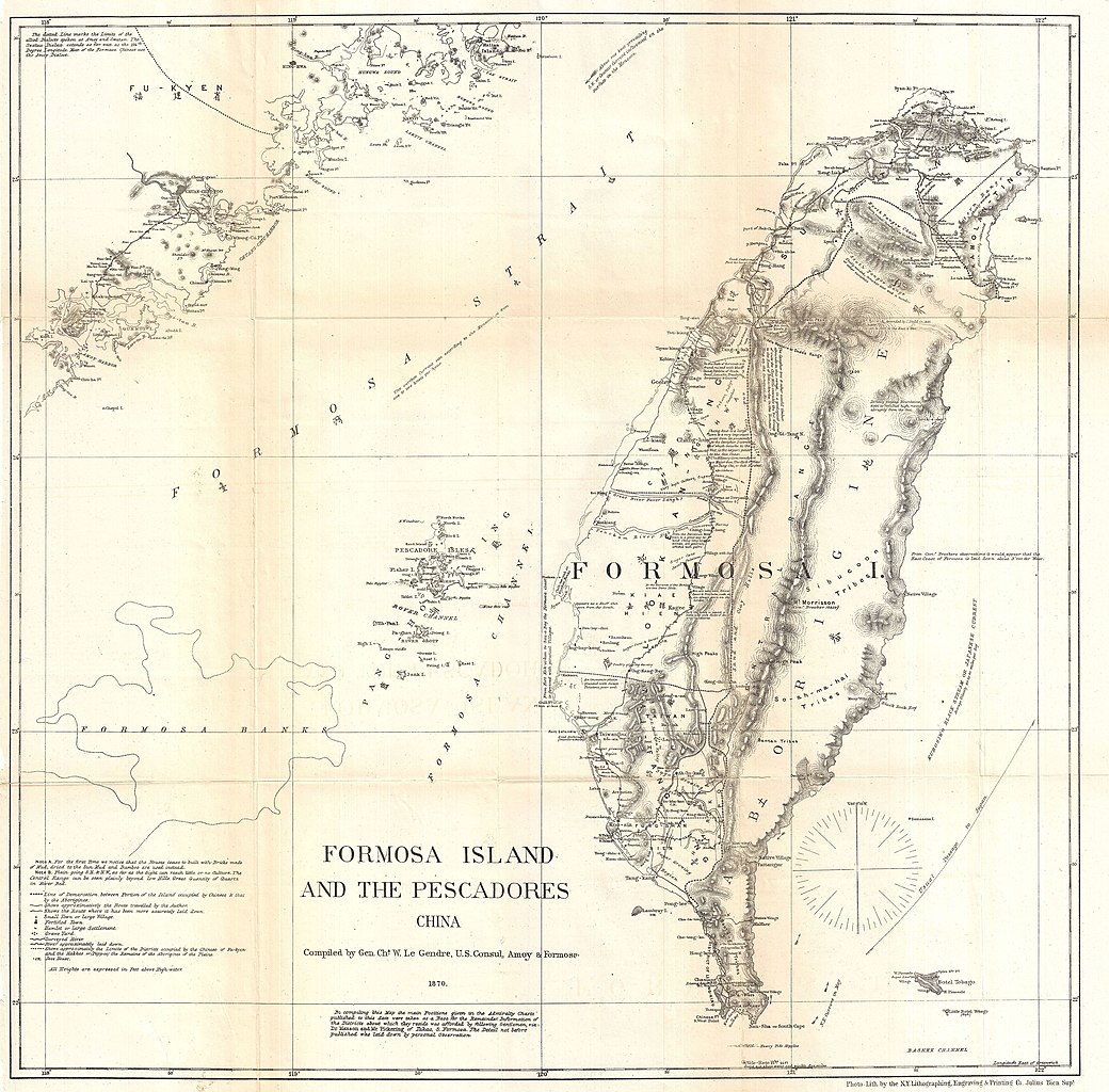
English: An extremely interesting, important, and uncommon map of Taiwan or Formosa issued in 1870 by the American Consul at Amoy, Charles W. Le Gendre. Focusing on the island of Formosa, this map covers from Fu-Kyen (Fukien), China to the Botel Tobago. Includes the Pang-Hoo-Ting Island, undersea features such as the Formosa Bank, and more inland detail than any map of Formosa previously published. This map originated with the unfortunate Rover Incident. The Rover was an American fishing vessel that shipwrecked in southern Formosa. Though the crew of the Rover was killed by the Taiwanese aboriginal population, it was widely assumed that they were alive and being held for ransom in the southern part of the Island. Le Gendre petitioned for and was granted the right to take an armed expedition into the region in the hopes of recovering the Americans. Though none of the Rover's crew remained alive, Le Gendre did succeed to producing the most sophisticated western map of the interior of Taiwan or Formosa to date. Though ostensibly a rescue mission, his study of Formosa is clearly laid out with commerce in mind, for his notes sugar growing regions, mineral (particularly coal) supplies, camphor districts, and woodlands are profuse. In the age of great steamships, coal was of particular interest as the U.S. need coal supply station in the China Sea region. It was known that the mountainous interior of Taiwan held considerable supplies of the precious commodity and part of Le Gendre's expedition involved finding ways to exploit it.
Reviewing this map one is immediately struck by the detail of western Taiwan as opposed to the relative emptiness of the eastern part of the island. At this time western Taiwan was a colony of the Fukien Chinese, just across the Formosa Strait. Their border extended inland to Taiwan's central range. Beyond the central Range was a little known region populated by diverse and often aggressively territorial aboriginal groups. The unique configuration of Le Gendre's Central Range, two large mountain chains embracing by an empty explored zone makes its first appearance here, but would be replicated on many subsequent maps; including British Admiralty Charts, well into the 1960s. This map was drawn by C. W. Le Gendre and engraved by Julius Bien of New York for publication in Le Gendre's 1874 Notes of Travel in Formosa - See more at: http://www.geographicus.com/P/AntiqueMap/FormosaTaiwan-gendre-1870#sthash.vkKa9BJ2.dpuf Date: 1870 (dated) Source: Le Gendre, C. W., Notes of Travel in Formosa, vol 4, plate 1, 1874. References: Library of Congress, G7910 1870 .L3 Vault (Le Gendres original manuscript). |
| 日期 | |
| 來源 | http://www.geographicus.com/P/AntiqueMap/FormosaTaiwan-gendre-1870 |
| 作者 | Charles William (Guillaum) Joseph Émile Le Gendre and Julius (Julien) Bien |
| 其他版本 |
|
_Satecha.jpg)


.jpg?uselang=zh-mo)
.jpg?uselang=zh-mo)
.jpg?action=history&uselang=zh-mo)
.jpg)
授權條款
|
此為如實地拍攝平面藝術品的相片複製本。原作位於公有領域,是因下列原因:
維基媒體基金會的官方立場認為:「針對平面公有領域的藝術作品進行忠實重製,其重製後的照片也屬於公有領域。」
因此,可認定本重製照片屬於公有領域。在其他司法管轄區,再利用此照片可能會被限制;參見再利用PD-Art照片以獲得進一步資訊。 | ||||
檔案歷史
點選日期/時間以檢視該時間的檔案版本。
| 日期/時間 | 縮圖 | 尺寸 | 用戶 | 備註 | |
|---|---|---|---|---|---|
| 目前 | 2022年9月18日 (日) 06:28 | | 4,000 × 3,938(2.39 MB) | Twistinez-Taiwaner | large version |
| 2014年5月7日 (三) 14:14 |  | 600 × 591(66 KB) | Hst0129 | User created page with UploadWizard |
檔案用途
全域檔案使用狀況
以下其他 wiki 使用了這個檔案:
- en.wiki.x.io 的使用狀況
.jpg)