原始檔案 (783 × 803 像素,檔案大小:170 KB,MIME 類型:image/jpeg


摘要

描述
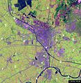
English: False-color satellite image of the Utrecht region with local Rhine branches indicated. The image was made by NLR and ESA.NLR and ESA are cited as its source.
日期 2004年8月24日 (原始上傳日期)
來源 Transferred from en.wikipedia to Commons by Pauk using CommonsHelper.
作者 原上傳者為英文維基百科Cwoyte

授權條款

© 本檔案的著作權持有者, NLR and ESA are cited as its source,在註明所有人姓名的前提下,允許任何人使用本檔案於任何用途。包含再散布、衍生作品、商業用途及其他用途。
姓名標示:
NLR and ESA are cited as its source


False-color satellite image of the Utrecht region with local Rhine branches indicated. The image was made by NLR and ESA. NLR and ESA are cited as its source.

  1. Part of the province of Gelderland
  2. Part of the province of Utrecht
  1. River Lek
  2. The Kromme Rijn stream
  3. River Vecht
  4. The Leidse RijnOude Rijn stream
  5. The Vaartse Rijn canal
  6. River Hollandse IJssel
  7. The Amsterdam-Rhine Canal

Category:Rhine–Meuse–Scheldt delta Category:Maps of the Netherlands}}

原始上傳日誌

The original description page was here. All following user names refer to en.wikipedia.
  • 2004-08-24 14:31 Cwoyte 783×803× (174163 bytes) Satellite image of the Utrecht region with Rhine branches indicated.

說明

添加單行說明來描述出檔案所代表的內容

在此檔案描寫的項目

描繪內容

著作權狀態 繁體中文 (已轉換拼寫)

有著作權 繁體中文 (已轉換拼寫)

僅需姓名標示授權條款 繁體中文 (已轉換拼寫)

檔案歷史

點選日期/時間以檢視該時間的檔案版本。

日期/時間縮⁠圖尺寸用戶備⁠註
目前2011年6月19日 (日) 02:52於 2011年6月19日 (日) 02:52 版本的縮圖783 × 803(170 KB)File Upload Bot (Magnus Manske) {{BotMoveToCommons|en.wikipedia|year={{subst:CURRENTYEAR}}|month={{subst:CURRENTMONTHNAME}}|day={{subst:CURRENTDAY}}}} {{Information |Description={{en|en:False-color satellite image of the Utrecht region with local [[:en:Rhin

下列頁面有用到此檔案:

全域檔案使用狀況

以下其他 wiki 使用了這個檔案:

詮釋資料