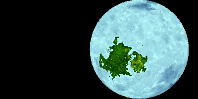
File:Diagram of the (conjectured) Vaalbara ancient continent.png

Diagram_of_the_(conjectured)_Vaalbara_ancient_continent.png (400 × 200像素,文件大小:29 KB,MIME类型:image/png


摘要

描述
English: This is a Diagram of the (conjectured) ancient continent of Vaalbara. Vaalbara is an assumed early super continent of earth. It is one of the oldest presumed parcels of land in Earth geological history. Vaalbara is composed of part of southern Africa (Shown in Dark Green) and the Pilbarar Region of Western Australia. Geology of these two regions indicates that when they were formed they were joined as one continent despite being quite separate today. These regions contain some of the oldest rocks on Earth. Despite being depicted in green, Vaalbara existed prior to the presumed advent of land plants and is assumed it would have been quite barren. This picture depicts Vaalbara as being the only continent at this time, however, this may or may not have been the case it is possible that other land (Now long gone due to geological recycling) existed at this time.
日期
来源 自己的作品
作者 D A R C 12345

许可协议

我,本作品著作权人,特此采用以下许可协议发表本作品:
w:zh:知识共享
署名 相同方式共享
您可以自由地:
  • 共享 – 复制、发行并传播本作品
  • 修改 – 改编作品
惟须遵守下列条件:
  • 署名 – 您必须对作品进行署名,提供授权条款的链接,并说明是否对原始内容进行了更改。您可以用任何合理的方式来署名,但不得以任何方式表明许可人认可您或您的使用。
  • 相同方式共享 – 如果您再混合、转换或者基于本作品进行创作,您必须以与原先许可协议相同或相兼容的许可协议分发您贡献的作品。

说明

添加一行文字以描述该文件所表现的内容
Diagram of the (conjectured) Vaalbara ancient continent

此文件中描述的项目

描绘内容

瓦巴拉大陆 中文(已转写)

文件历史

点击某个日期/时间查看对应时刻的文件。

日期/时间缩⁠略⁠图大小用户备注
当前2019年9月30日 (一) 13:122019年9月30日 (一) 13:12版本的缩略图400 × 200(29 KB)D A R C 12345User created page with UploadWizard

以下页面使用本文件:

全域文件用途

以下其他wiki使用此文件:

元数据