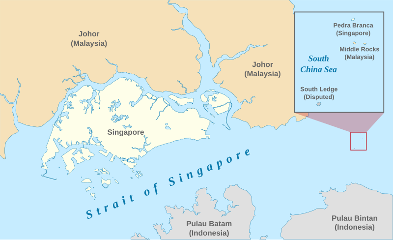
File:Pedra Branca Map.svg

此SVG文件的PNG预览的大小:800 × 487像素。 其他分辨率:320 × 195像素 | 640 × 390像素 | 1,024 × 624像素 | 1,280 × 779像素 | 2,560 × 1,559像素 | 3,478 × 2,118像素。
原始文件 (SVG文件,尺寸为3,478 × 2,118像素,文件大小:230 KB)
文件历史
点击某个日期/时间查看对应时刻的文件。
| 日期/时间 | 缩略图 | 大小 | 用户 | 备注 | |
|---|---|---|---|---|---|
| 当前 | 2021年1月13日 (三) 06:27 |  | 3,478 × 2,118(230 KB) | Seloloving | recoloured to Wikipedia map colour style |
| 2020年2月9日 (日) 09:59 |  | 3,478 × 2,118(219 KB) | *angys* | File uploaded using svgtranslate tool (https://tools.wmflabs.org/svgtranslate/). Added translation for zh. | |
| 2017年10月22日 (日) 14:36 |  | 3,478 × 2,118(208 KB) | Seloloving | Fixed spelling error with "Enlargement" | |
| 2017年10月22日 (日) 14:34 |  | 3,478 × 2,118(208 KB) | Seloloving | Recolored claimant states to a more neutral colour. Shifted the Insert Map further up and added note to clarify its actual location. Changed fonts and colours to align with Wikipedia Map guidelines. | |
| 2014年5月24日 (六) 19:42 |  | 3,261 × 1,986(194 KB) | Seloloving | Fixed text rendering. Fixed map. | |
| 2014年5月4日 (日) 05:36 |  | 3,261 × 1,986(276 KB) | Seloloving | Fixed Johor's shape. | |
| 2014年5月4日 (日) 05:24 |  | 3,261 × 1,986(274 KB) | Seloloving | Fixed font problems. | |
| 2014年5月4日 (日) 05:20 |  | 3,261 × 1,986(273 KB) | Seloloving | Fixed problems. | |
| 2014年5月4日 (日) 05:12 |  | 3,261 × 1,986(282 KB) | Seloloving | Fixed geography of the islands. | |
| 2008年9月30日 (二) 04:05 |  | 3,261 × 1,986(396 KB) | Jappalang | "South Lodge" corrected to "South Ledge" |
文件用途
以下2个页面使用本文件:
全域文件用途
以下其他wiki使用此文件:
- de.wiki.x.io上的用途
- en.wiki.x.io上的用途
- es.wiki.x.io上的用途
- fr.wiki.x.io上的用途
- he.wiki.x.io上的用途
- hy.wiki.x.io上的用途
- id.wiki.x.io上的用途
- it.wiki.x.io上的用途
- ja.wiki.x.io上的用途
- ko.wiki.x.io上的用途
- mdf.wiki.x.io上的用途
- ms.wiki.x.io上的用途
- pt.wiki.x.io上的用途
- ru.wiki.x.io上的用途
- sh.wiki.x.io上的用途
- ta.wiki.x.io上的用途
- th.wiki.x.io上的用途
- vi.wiki.x.io上的用途
