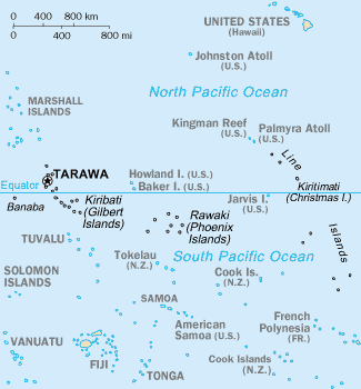
File:Map of Kiribati CIA WFB.png
Map_of_Kiribati_CIA_WFB.png (325 × 350像素,文件大小:9 KB,MIME类型:image/png)
文件历史
点击某个日期/时间查看对应时刻的文件。
| 日期/时间 | 缩略图 | 大小 | 用户 | 备注 | |
|---|---|---|---|---|---|
| 当前 | 2010年9月17日 (五) 15:35 |  | 325 × 350(9 KB) | Ras67 | cropped |
| 2005年3月27日 (日) 09:15 |  | 330 × 354(10 KB) | Wolfman~commonswiki | {{CIA-map}} |
文件用途
以下4个页面使用本文件:
全域文件用途
以下其他wiki使用此文件:
- af.wiki.x.io上的用途
- avk.wiki.x.io上的用途
- azb.wiki.x.io上的用途
- ban.wiki.x.io上的用途
- bjn.wiki.x.io上的用途
- br.wiki.x.io上的用途
- bs.wiki.x.io上的用途
- ceb.wiki.x.io上的用途
- cs.wiki.x.io上的用途
- da.wiki.x.io上的用途
- de.wikivoyage.org上的用途
- en.wiki.x.io上的用途
- Howland Island
- Jarvis Island
- Line Islands
- Tabuaeran
- List of towns and villages in Kiribati
- Lists of hospitals in Oceania
- Talk:List of sovereign states and dependent territories in Oceania
- List of airports in Kiribati
- Wikipedia:Featured picture candidates/February-2007
- Wikipedia:Featured picture candidates/Kingman Reef
- Outline of Kiribati
- Wikipedia:Graphics Lab/Image workshop/Archive/Nov 2008
- Ministry of Line and Phoenix Islands Development
- en.wikisource.org上的用途
- en.wikiversity.org上的用途
- eo.wiki.x.io上的用途
- es.wiki.x.io上的用途
- et.wiki.x.io上的用途
- eu.wiki.x.io上的用途
- fa.wiki.x.io上的用途
- fi.wiki.x.io上的用途
查看此文件的更多全域用途。


