File:Anachronous map of the All French Empire (1534 -1970).png
本预览的尺寸:800 × 406像素。 其他分辨率:320 × 162像素 | 640 × 325像素 | 1,024 × 520像素 | 2,000 × 1,015像素。
原始文件 (2,000 × 1,015像素,文件大小:505 KB,MIME类型:image/png)
.png?uselang=zh)
.png?uselang=zh)
.png?action=history&uselang=zh)
.png)
摘要
| 描述 |
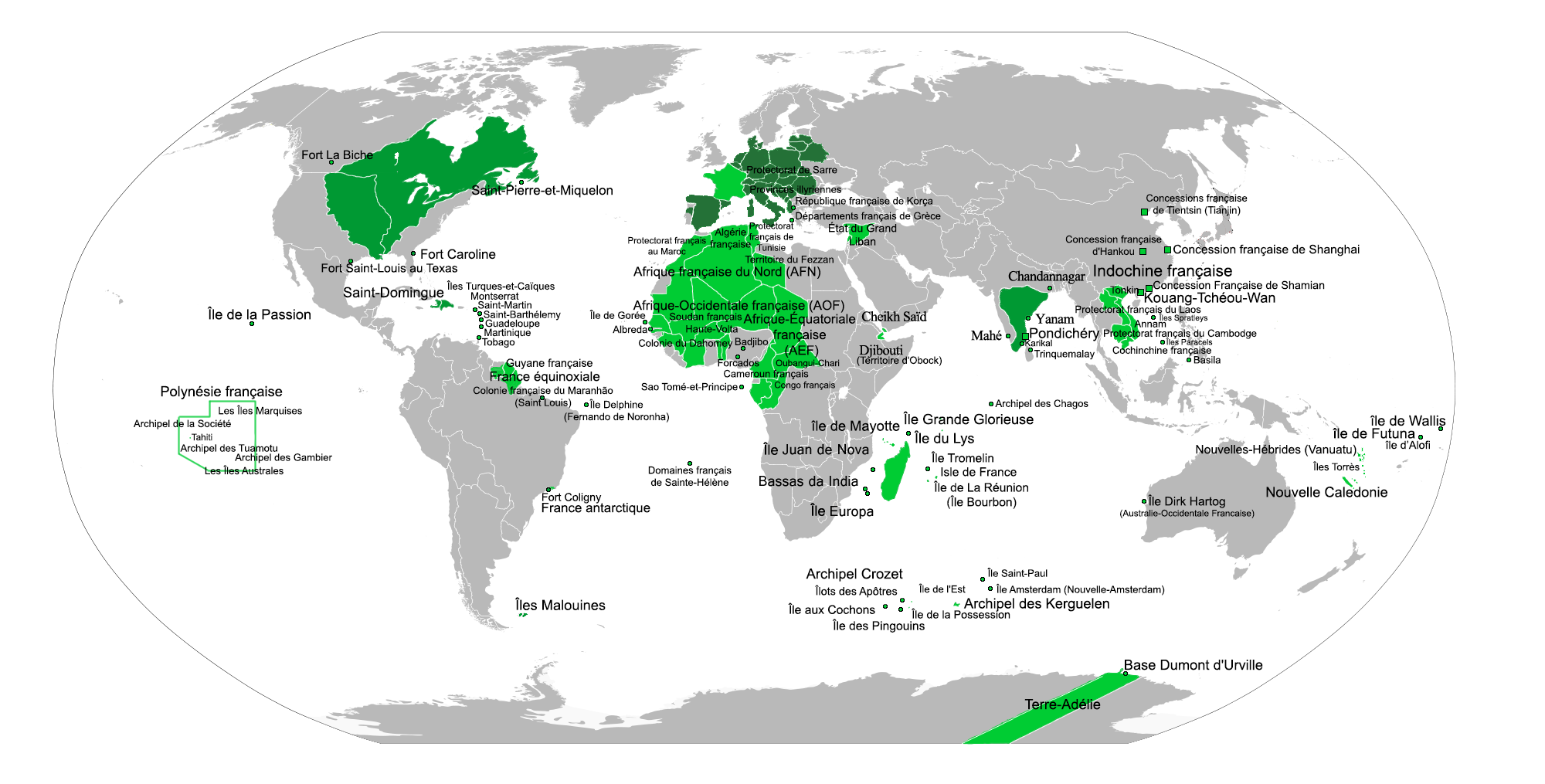
English: Map of the whole French Empire,
In dark green, the first colonial empire (French control was somewhat nominal over some of this area) In light green the second colonial empireFrançais : Carte de tout l'Empire Français,
En vert foncé, le 1er Empire colonial En vert clair, le 2eme Empire colonial |
| 日期 | |
| 来源 | 自己的作品 |
| 作者 | Gd21091993 |
| 其他版本 | العربيَّة |
-ar.png)
许可协议
| 我,本作品著作权人,释出本作品至公有领域。这适用于全世界。 在一些国家这可能不合法;如果是这样的话,那么: 我无条件地授予任何人以任何目的使用本作品的权利,除非这些条件是法律规定所必需的。 |
文件历史
点击某个日期/时间查看对应时刻的文件。
| 日期/时间 | 缩略图 | 大小 | 用户 | 备注 | |
|---|---|---|---|---|---|
| 当前 | 2015年6月12日 (五) 04:33 | | 2,000 × 1,015(505 KB) | Hypersite | Added territories with exact names. |
| 2015年6月6日 (六) 20:34 |  | 2,000 × 1,015(445 KB) | Hypersite | French Concession of Tientsin Added. French Polynesia detailed French Republic of Korca added. | |
| 2015年6月6日 (六) 08:13 |  | 2,000 × 1,015(429 KB) | Hypersite | Errors corrected and territories added. | |
| 2012年2月13日 (一) 01:46 |  | 2,000 × 1,015(357 KB) | Shid0x02 | Renamed ''Rio de Janeiro'' to ''Fort Coligny'' since the french colonized only this part. | |
| 2012年2月13日 (一) 01:33 |  | 2,000 × 1,015(357 KB) | Shid0x02 | Added some part to the first colonial empire : Sao Luis,Rio,the falkland islands. Added the some part to the second colonial empire : French India,Vanuatu. All these add have been verified with actual wikipedia articles and external sources,you can see f | |
| 2011年9月26日 (一) 22:58 |  | 2,000 × 1,015(657 KB) | TarEldamir | Reverted to version as of 19:45, 17 November 2010 / Reverting to the more plausible version. | |
| 2011年3月20日 (日) 13:16 |  | 2,000 × 1,015(648 KB) | Picaballo | + Dirk Atog Island (Australia) + Fort Carolina (Floride) + France antarctique (Brasil) + France equinoxiale (Brasil) + Vanuatu | |
| 2011年3月1日 (二) 11:21 |  | 2,000 × 1,015(642 KB) | Picaballo | * Ajout de la Campagne d'Egypte + des 5 Comptoirs français aux Indes * Grisement de du Fezzan et de l'Egypte | |
| 2010年11月17日 (三) 19:45 |  | 2,000 × 1,015(657 KB) | Gd21091993 | {{Information |Description={{en|1=Map of the all French Empire, In dark green, the first empire colonial In light green the second empire colonial}} {{fr|1=Carte de tout les Empires Français, En vert foncé, le 1er Empire coloniale En vert clair, le 2em |
文件用途
以下2个页面使用本文件:
全域文件用途
以下其他wiki使用此文件:
- af.wiki.x.io上的用途
- ar.wiki.x.io上的用途
- azb.wiki.x.io上的用途
- ba.wiki.x.io上的用途
- br.wiki.x.io上的用途
- en.wiki.x.io上的用途
- es.wiki.x.io上的用途
- fa.wiki.x.io上的用途
- fr.wiki.x.io上的用途
- hy.wiki.x.io上的用途
- id.wiki.x.io上的用途
- it.wiki.x.io上的用途
- ms.wiki.x.io上的用途
- ru.wiki.x.io上的用途
- th.wiki.x.io上的用途
- tt.wiki.x.io上的用途
.png)