库特内河
北美洲河流
库特内河(英語:Kootenay或Kootenai[5],也被称作Flatbow[6])是哥伦比亚河的一条重要支流,流经加拿大卑诗省的东南部和美国西北部的爱达荷州与蒙大拿州,全长781公里(485英里),起源于加拿大落基山脉,在卡斯尔加注入哥伦比亚河,最终注入太平洋。
| 库特内河 Kootenay | |
|---|---|
 库特内河一景,位于蒙大拿州利比大坝下游 | |
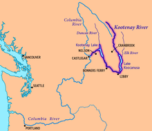
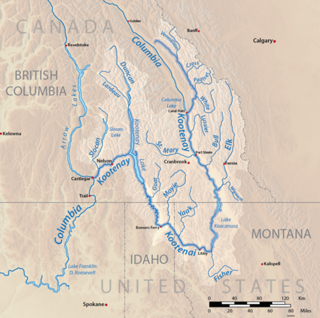
 库特内河地图,标出了主要城市与湖泊 | |
| 别名 | Kootenai、Flatbow、Swan |
| 國家 | |
| 州/省 | |
| 流域 | |
| 源頭 | South flank of Castle Mountain |
| • 位置 | 加拿大卑诗省Beaverfoot Range |
| • 坐标 | 51°02′21″N 116°26′33″W / 51.03917°N 116.44250°W[1] |
| • 海拔 | 2,261米(7,418英尺)[1] |
| 河口 | 哥伦比亚河 |
| • 位置 | 加拿大卑诗省卡斯尔加 |
| • 坐标 | 49°19′0″N 117°39′4″W / 49.31667°N 117.65111°W |
| • 海拔 | 420米(1,380英尺)[2] |
| 流域面積 | 50,298 km2(19,420 sq mi)[2] |
| 城市 | 利比、邦納斯費里、Creston, BC、Nelson, BC、卡斯尔加 |
| 本貌 | |
| 長度 | 780 km(480 mi) |
| 流量 | |
| • 地點 | Corra Linn, BC |
| • 平均流量 | 782 m3/s(27,600 cu ft/s)[3][4] |
| • 最小流量 | 104 m3/s(3,700 cu ft/s) |
| • 最大流量 | 4,930 m3/s(174,000 cu ft/s) |
| 特徵 | |
| 左岸支流 | Palliser River、White River、Bull River、麋鹿河、Fisher River、Tobacco River、Lake Creek |
| 右岸支流 | St. Mary River、Yaak River、Moyie River、Goat River、Duncan River、Slocan River |

参考文献
编辑- ^ 1.0 1.1 Source elevations and coordinates derived from Google Earth using data from Canadian topo maps
- ^ 2.0 2.1 The Rivers - Stories. Balance of Power. 2007 [September 3, 2008]. (原始内容存档于2011年11月6日).
- ^ Kootenay Lake Outflow Near Corra Linn – Monthly Mean Discharge. HYDAT Archived Hydrometric Data. Environment Canada. 1937–2010 [2011-11-25]. (原始内容存档于2012-04-21).
- ^ Kootenai River Basin - Hydrology. International Alliance for Water Quality and Aquatic Resources. Kootenai River Network, Inc. 2010-03-14 [2010-03-25]. (原始内容存档于2007-09-06).
- ^ 美國地質調查局地名資訊系統:Kootenai River
- ^ Palliser, John. Exploration - British North America - the journals, detailed reports, and observations relative to the exploration, by Captain Palliser, of that portion of British North America, which, in latitude, lies between the British boundary line and the height of land or watershed of the northern or .... G.E. Eyre and W. Spottiswoode for H.M. Stationery Off. 1863: 162.